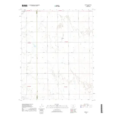
2018 Map of Corwin
USGS Topo · Published 2018About this map
Corwin sits at the heart of this rural landscape on the border of Barber and Harper Counties, where the high plains begin to break into the drainage basins of the southern Kansas borderlands. The terrain is defined by the winding course of the Medicine Lodge River in the southwest corner and the dendritic patterns of Little Sandy Cr and Salty Cr. These waterways create a natural contrast to the rigid grid of section line roads that organize the agricultural territory. Local landmarks such as Hargis Lake and the historically named Black Kettle road provide specific points of reference for researchers of this prairie region. The map documents the persistent infrastructure of the area, from established routes like Gerlane Rd and Driftwood Rd to the crossing at Rattlesnake Trl, illustrating the intersection of modern transport and original natural geography.
Find a feature on this map
36 named features on this map. Tap any name to fly to it.
Don’t see what you’re looking for? This feature index may not catch every label — zoom into the map to look around manually.
Map Details
Editions of this 2018 Corwin Map
This is the sole edition of this map. No revisions or reprints were ever made.
Other maps of this area

1889 · Anthony
USGS Topo · 1:125,000

1891 · Anthony
USGS Topo · 1:125,000

1955 · Woodward
USGS Topo · 1:250,000

1955 · Pratt
USGS Topo · 1:250,000

1958 · Woodward
USGS Topo · 1:250,000

1959 · Pratt
USGS Topo · 1:250,000

1969 · Amorita
USGS Topo · 1:24,000

1969 · Burlington
USGS Topo · 1:24,000
1969 · Manchester NW
USGS Topo · 1:24,000

1972 · Attica
USGS Topo · 1:24,000