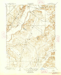
1909 Map of Cosumnes
USGS Topo · Published 1947About this map
Cosumnes River corridors and rural schoolhouses define this 1907 survey of eastern Sacramento County. The landscape is marked by the winding path of Deer Creek and the southern reach of Laguna, where the terrain transitions from river bottoms to upland plains. Slough House and the settlement of Cosumne stand as primary hubs of activity along the historic Jackson Road, which served as a vital freight and travel artery for the region. The map reveals a decentralized educational network of the early twentieth century, with family-named landmarks such as Rhoads School, Wilson School, and Lee School positioned to serve the surrounding ranching and agricultural community. These small, scattered school sites provide significant genealogical clues, anchoring the rural population to specific parcels before the era of district consolidation.
Find a feature on this map
9 named features on this map. Tap any name to fly to it.
Don’t see what you’re looking for? This feature index may not catch every label — zoom into the map to look around manually.
Map Details
Editions of this 1909 Cosumnes Map
2 editions found
Other maps of this area

1891 · Sacramento
USGS Topo · 1:125,000

1892 · Sacramento
USGS Topo · 1:125,000

1893 · Sacramento
USGS Topo · 1:125,000

1894 · Lodi
USGS Topo · 1:125,000

1902 · Fairoaks
USGS Topo · 1:62,500

1908 · Buffalo Creek
USGS Topo · 1:31,680

1909 · Elk Grove
USGS Topo · 1:31,680

1909 · Carbondale
USGS Topo · 1:31,680

1909 · Clay
USGS Topo · 1:31,680

1909 · Cosumnes
USGS Topo · 1:31,680