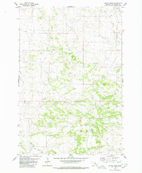
1980 Map of Cotton Creek
USGS Topo · Published 1980About this map
Billings Bench Water Association Canal cuts across the southern portion of this landscape, illustrating the critical role of engineered irrigation in Montana's agricultural development during the late 20th century. This area is defined by a series of branching drainages that move water through the high plains, including Pompeys Pillar Creek and its West Fork in the northeast, and the North Fork Cotton Creek winding through the center. Numerous scattered wells across the terrain suggest active resource extraction or water management, while the presence of Rock Creek and Razor Creek further defines the hydrological network. The mapping reveals a sparse, rural pattern where water access, both natural and man-made, dictates the utility of the land.
Find a feature on this map
7 named features on this map. Tap any name to fly to it.
Don’t see what you’re looking for? This feature index may not catch every label — zoom into the map to look around manually.
Map Details
Editions of this 1980 Cotton Creek Map
This is the sole edition of this map. No revisions or reprints were ever made.
Other maps of this area

1893 · Huntley
USGS Topo · 1:125,000

1954 · Billings
USGS Topo · 1:250,000

1954 · Roundup
USGS Topo · 1:250,000

1956 · Rattlesnake Butte
USGS Topo · 1:24,000

1956 · Huntley
USGS Topo · 1:24,000

1957 · Billings
USGS Topo · 1:250,000

1958 · Billings
USGS Topo · 1:250,000

1958 · Roundup
USGS Topo · 1:250,000

1967 · Worden
USGS Topo · 1:24,000

1979 · Roundup
USGS Topo · 1:100,000