
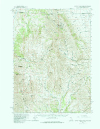
1959 Map of Cotton Thomas Basin
USGS Topo · Published 1960About this map
Mining operations and historical remnants dominate the high country along the Idaho-Utah border in this late 1950s survey. The northeast portion of the map reveals a concentrated cluster of industrial activity including the Vipont Mine, Skoro Mine, and several specialized features like the Phelan Tunnel and Harrison Tunnel. These workings are situated near Middle Mtn and Granite Pass, indicating a period of significant geological exploration in the region.
Find a feature on this map
74 named features on this map. Tap any name to fly to it.
Don’t see what you’re looking for? This feature index may not catch every label — zoom into the map to look around manually.
Map Details
Editions of this 1959 Cotton Thomas Basin Map
2 editions found
Other maps of this area

1954 · Pocatello
USGS Topo · 1:250,000

1954 · Brigham City
USGS Topo · 1:250,000

1955 · Twin Falls
USGS Topo · 1:250,000

1955 · Wells
USGS Topo · 1:250,000

1958 · Wells
USGS Topo · 1:250,000

1958 · Twin Falls
USGS Topo · 1:250,000

1958 · Pocatello
USGS Topo · 1:250,000

1958 · Brigham City
USGS Topo · 1:250,000

1959 · Yost
USGS Topo · 1:62,500

1961 · Wells
USGS Topo · 1:250,000