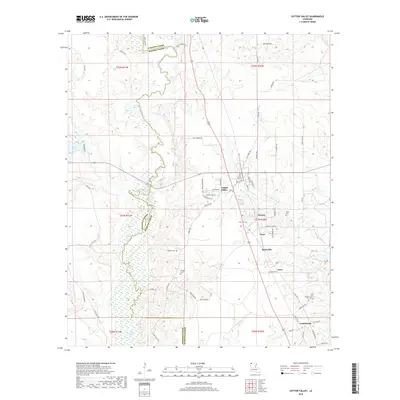
2018 Map of Cotton Valley
USGS Topo · Published 2018About this map
Cotton Valley serves as the primary hub of this north Louisiana landscape, where the meandering course of Bodcau Creek marks the boundary between Webster Parish and Bossier Parish. The town’s grid, featuring streets such as Webster St and Egan St, gives way to a network of rural routes and family-named roads like Wenk s Landing Rd and Hayes Farm Rd. To the south and east, several small named locales including Dayson, Treat, Invincible, and Ecco indicate the historical footprint of earlier communities across the terrain. Genealogists will find particular value in the documentation of local burial sites, such as Flaherty Cem, Hodges Cem, and the Banks Sandlin Cem near the southern border. The landscape is further defined by its water features, ranging from the broad Ivan Lake to the north to smaller bodies like Bong Lake and Coile Pond.
Find a feature on this map
71 named features on this map. Tap any name to fly to it.
Don’t see what you’re looking for? This feature index may not catch every label — zoom into the map to look around manually.
Map Details
Editions of this 2018 Cotton Valley Map
This is the sole edition of this map. No revisions or reprints were ever made.
Other maps of this area

1922 · Sarepta
USGS Topo · 1:62,500

1924 · Sarepta
USGS Topo · 1:62,500

1932 · Bossier NE
USGS Topo · 1:31,680

1947 · Minden
USGS Topo · 1:62,500

1948 · Bossier City
USGS Topo · 1:62,500

1949 · Minden
USGS Topo · 1:62,500

1950 · Plain Dealing NE
USGS Topo · 1:31,680

1950 · Plain Dealing SE
USGS Topo · 1:31,680

1953 · Carterville
USGS Topo · 1:24,000

1955 · Shreveport
USGS Topo · 1:250,000