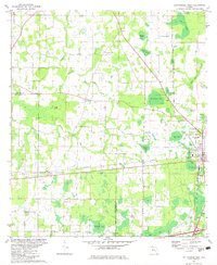
1982 Map of Cottondale West
USGS Topo · Published 1983About this map
Cottondale serves as the regional hub for this portion of the Florida Panhandle, situated at the busy intersection of the Louisville and Nashville and Atlanta and St Andrews Bay railroads. The landscape is a network of cypress-rich wetlands and named "bays" such as Drummond Bay, Big Bay, and Melvin Bay, which define the low-lying terrain between Jackson and Washington Counties. Outside the main town, the 1970s field-checked data shows a rural community anchored by small settlements like Loyewood and Glass, and a significant number of country churches including Pilgrim Rest Ch, Oak Grove Ch, and Friendship Ch. The presence of several family-named watercourses like Gilberts Mill Creek and Russ Mill Creek suggests a history of local industry tied to the region's abundant water and timber resources.
Find a feature on this map
38 named features on this map. Tap any name to fly to it.
Don’t see what you’re looking for? This feature index may not catch every label — zoom into the map to look around manually.
Map Details
Editions of this 1982 Cottondale West Map
This is the sole edition of this map. No revisions or reprints were ever made.
Other maps of this area

1950 · Chipley
USGS Topo · 1:24,000

1950 · Wausau
USGS Topo · 1:24,000

1951 · Graceville
USGS Topo · 1:24,000

1951 · Chipley
USGS Topo · 1:24,000

1951 · Wausau
USGS Topo · 1:24,000

1952 · Kynesville
USGS Topo · 1:24,000

1952 · Cottondale East
USGS Topo · 1:24,000

1952 · Campbellton
USGS Topo · 1:24,000

1952 · Cottondale West
USGS Topo · 1:24,000

1952 · Sills
USGS Topo · 1:24,000