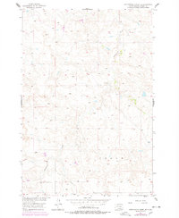
1956 Map of Cottonwood Creek SE
USGS Topo · Published 1978About this map
The Cedar township boundary and the winding course of Cottonwood Creek define this landscape within the Standing Rock Indian Reservation. This map reflects a transition in documentation, based on 1950s field checks and revised with 1970s aerial photography to track topographic shifts in Corson County. The terrain is characterized by a series of landforms like Smiley, situated north of the creek, which provide a window into the natural landmarks used for navigation in this section of the Missouri River Basin. This survey was specifically edited for the Department of the Interior's program for basin development, providing an official record of the region’s topography before later modern land-use changes.
Find a feature on this map
3 named features on this map. Tap any name to fly to it.
Don’t see what you’re looking for? This feature index may not catch every label — zoom into the map to look around manually.
Map Details
Editions of this 1956 Cottonwood Creek SE Map
2 editions found
Other maps of this area

1953 · McIntosh
USGS Topo · 1:250,000

1956 · Black Horse SW
USGS Topo · 1:24,000

1956 · Cottonwood Creek NE
USGS Topo · 1:24,000

1956 · Black Horse
USGS Topo · 1:24,000

1956 · Cottonwood Creek SE
USGS Topo · 1:24,000

1956 · Cottonwood Creek NW
USGS Topo · 1:24,000

1956 · Cottonwood Creek SW
USGS Topo · 1:24,000

1958 · McIntosh
USGS Topo · 1:250,000

1978 · Isabel
USGS Topo · 1:24,000

1980 · McIntosh
USGS Topo · 1:100,000