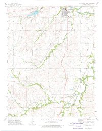
1973 Map of Cottonwood Falls
USGS Topo · Published 1975About this map
Cottonwood Falls and the surrounding Flint Hills landscape are documented here in the early 1970s, showcasing the intersection of the Cottonwood River and the Atchison Topeka and Santa Fe railroad. The map highlights the town's role as a regional center, featuring the Chase County Airport, Swope Park, and the local Sewage Disposal Ponds. To the west, the Chase County State Lake is a prominent water body, fed by numerous creeks including Diamond Creek and Prather Creek. The southern portion of the map centers on Bazaar, a smaller settlement near the South Fork Cottonwood River. The terrain is marked by numerous quarries, indicating the importance of local limestone extraction. Long-standing local landmarks like Prairie Grove Cem and the Bazaar Cem provide essential data for those researching family history in Chase County.
Find a feature on this map
27 named features on this map. Tap any name to fly to it.
Don’t see what you’re looking for? This feature index may not catch every label — zoom into the map to look around manually.
Map Details
Editions of this 1973 Cottonwood Falls Map
This is the sole edition of this map. No revisions or reprints were ever made.
Other maps of this area

1888 · Emporia
USGS Topo · 1:125,000

1894 · Emporia
USGS Topo · 1:125,000

1898 · Cottonwood Falls
USGS Topo · 1:125,000

1955 · Hutchinson
USGS Topo · 1:250,000

1957 · Elmdale
USGS Topo · 1:24,000

1957 · Strong City
USGS Topo · 1:24,000

1957 · Saffordville
USGS Topo · 1:24,000

1957 · Hymer
USGS Topo · 1:24,000

1959 · Hutchinson
USGS Topo · 1:250,000

1973 · Matfield Green
USGS Topo · 1:24,000