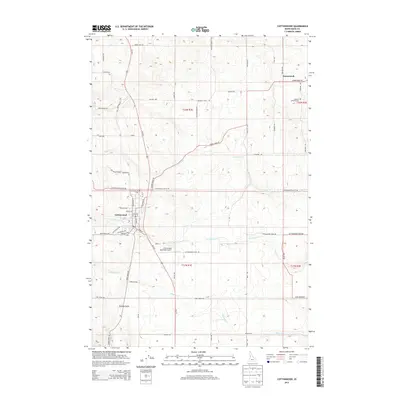
2013 Map of Cottonwood
USGS Topo · Published 2013About this map
Cottonwood serves as the central hub of this agricultural and plateau landscape, where the street grid of the town site is detailed with prominent thoroughfares such as Main St and Lewiston St. The surrounding terrain is defined by a series of drainages, including Stockney Cr, Cottonwood Cr, and Shebang Cr, which carve through the high country. To the northeast, the smaller settlement of Greencreek sits near the Saint Anthony Cem, reflecting the early 20th-century Catholic heritage of the Camas Prairie region.
Find a feature on this map
54 named features on this map. Tap any name to fly to it.
Don’t see what you’re looking for? This feature index may not catch every label — zoom into the map to look around manually.
Map Details
Editions of this 2013 Cottonwood Map
This is the sole edition of this map. No revisions or reprints were ever made.
Other maps of this area

1924 · Kamiah
USGS Topo · 1:125,000

1955 · Pullman
USGS Topo · 1:250,000

1955 · Grangeville
USGS Topo · 1:250,000

1958 · Pullman
USGS Topo · 1:250,000

1959 · Grangeville
USGS Topo · 1:250,000

1963 · Grangeville West
USGS Topo · 1:24,000

1963 · Moughmer Point
USGS Topo · 1:24,000
1963 · Fenn
USGS Topo · 1:24,000

1967 · Craigmont
USGS Topo · 1:24,000
1967 · Nezperce SW
USGS Topo · 1:24,000