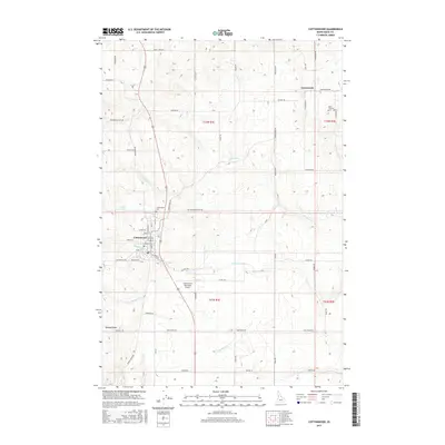
2017 Map of Cottonwood
USGS Topo · Published 2017About this map
The city of Cottonwood serves as the central hub of this Idaho County landscape, where the plateau terrain is divided by a network of drainage systems including Cottonwood Cr and Shebang Cr. The map details the transition from the concentrated residential and commercial blocks of the town center—intersected by Main St and Front St—to the expansive agricultural sections surrounding it. To the northeast, the small settlement of Greencreek sits near the headwaters of its namesake stream, Greencreek, marking a secondary node of community life in this high-prairie region.
Find a feature on this map
56 named features on this map. Tap any name to fly to it.
Don’t see what you’re looking for? This feature index may not catch every label — zoom into the map to look around manually.
Map Details
Editions of this 2017 Cottonwood Map
This is the sole edition of this map. No revisions or reprints were ever made.
Other maps of this area

1924 · Kamiah
USGS Topo · 1:125,000

1955 · Pullman
USGS Topo · 1:250,000

1955 · Grangeville
USGS Topo · 1:250,000

1958 · Pullman
USGS Topo · 1:250,000

1959 · Grangeville
USGS Topo · 1:250,000

1963 · Grangeville West
USGS Topo · 1:24,000

1963 · Moughmer Point
USGS Topo · 1:24,000
1963 · Fenn
USGS Topo · 1:24,000

1967 · Craigmont
USGS Topo · 1:24,000
1967 · Nezperce SW
USGS Topo · 1:24,000