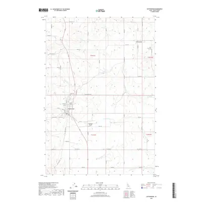
2020 Map of Cottonwood
USGS Topo · Published 2020About this map
The high plateau of Idaho County unfolds in this recent topographic study, centered on the historic agricultural hub of Cottonwood. The town’s grid, defined by streets like Main St and Maple St, anchors a landscape where human industry meets the drainage networks of Stockney Creek and Cottonwood Creek. The rural outskirts are marked by long-standing community fixtures, including Saint Anthony Cemetery near Greencreek and the Cottonwood Cemetery situated just west of the primary settlement.
Find a feature on this map
57 named features on this map. Tap any name to fly to it.
Don’t see what you’re looking for? This feature index may not catch every label — zoom into the map to look around manually.
Map Details
Editions of this 2020 Cottonwood Map
This is the sole edition of this map. No revisions or reprints were ever made.
Other maps of this area

1924 · Kamiah
USGS Topo · 1:125,000

1955 · Pullman
USGS Topo · 1:250,000

1955 · Grangeville
USGS Topo · 1:250,000

1958 · Pullman
USGS Topo · 1:250,000

1959 · Grangeville
USGS Topo · 1:250,000

1963 · Grangeville West
USGS Topo · 1:24,000

1963 · Moughmer Point
USGS Topo · 1:24,000
1963 · Fenn
USGS Topo · 1:24,000

1967 · Craigmont
USGS Topo · 1:24,000
1967 · Nezperce SW
USGS Topo · 1:24,000