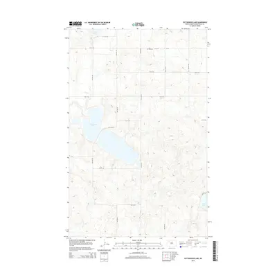
2014 Map of Cottonwood Lake
USGS Topo · Published 2014About this map
Cottonwood Lake dominates this portion of Mountrail County, surrounded by a precise grid of rural roads such as 89th Ave NW and 71st St NW. The landscape is typical of the North Dakota pothole region, where glacial depressions have created a network of water bodies including Powers Lake to the north and the smaller White Lake in the southeast. A significant site for local history is the Lunds Valley Cem, located along 74th St NW. This cemetery serves as a focal point for the surrounding agricultural community, where the land is divided by county roads like Cr-3104. The map's detailed contour lines illustrate the subtle variations in elevation that define the drainage patterns between these distinct prairie lakes.
Find a feature on this map
18 named features on this map. Tap any name to fly to it.
Don’t see what you’re looking for? This feature index may not catch every label — zoom into the map to look around manually.
Map Details
Editions of this 2014 Cottonwood Lake Map
This is the sole edition of this map. No revisions or reprints were ever made.
Other maps of this area

1953 · Williston
USGS Topo · 1:250,000

1957 · Williston
USGS Topo · 1:250,000

1969 · Ross NW
USGS Topo · 1:24,000

1969 · Stanley
USGS Topo · 1:24,000

1974 · Lostwood Lakes
USGS Topo · 1:24,000

1977 · Powers Lake
USGS Topo · 1:24,000
1978 · Lunds Valley
USGS Topo · 1:24,000

1981 · Ross
USGS Topo · 1:24,000

1981 · Manitou
USGS Topo · 1:24,000

1981 · Lostwood
USGS Topo · 1:24,000