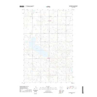
2020 Map of Cottonwood Lake
USGS Topo · Published 2020About this map
Cottonwood Lake dominates the central landscape of this western North Dakota quadrangle, reflecting the characteristic prairie pothole topography of the region. The map preserves the rural geometry of Township 158 North, Range 92 West and Township 157 North, Range 92 West, where a network of gravel roads like 74th St NW and 89th Ave NW follow the section lines. Near the northern boundary, the Lunds Valley Cemetery stands as a significant point for genealogical research, marking the community history of this remote agricultural area. To the southeast, the shoreline of White Lake appears along the margin, further illustrating the wetland-rich environment of the Missouri Coteau. This 2020 survey provides a precise modern look at the land's elevation and surface water distribution before further landscape shifts occur.
Find a feature on this map
19 named features on this map. Tap any name to fly to it.
Don’t see what you’re looking for? This feature index may not catch every label — zoom into the map to look around manually.
Map Details
Editions of this 2020 Cottonwood Lake Map
This is the sole edition of this map. No revisions or reprints were ever made.
Other maps of this area

1953 · Williston
USGS Topo · 1:250,000

1957 · Williston
USGS Topo · 1:250,000

1969 · Ross NW
USGS Topo · 1:24,000

1969 · Stanley
USGS Topo · 1:24,000

1974 · Lostwood Lakes
USGS Topo · 1:24,000

1977 · Powers Lake
USGS Topo · 1:24,000
1978 · Lunds Valley
USGS Topo · 1:24,000

1981 · Ross
USGS Topo · 1:24,000

1981 · Manitou
USGS Topo · 1:24,000

1981 · Lostwood
USGS Topo · 1:24,000