
1961 Map of Cottonwood NE
USGS Topo · Published 1963About this map
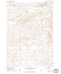
The Chicago and North Western railroad corridor defines the northern reaches of this western South Dakota landscape, tracking just below the Haakon and Jackson County line. The terrain is a complex network of seasonal drainages and creek beds, including the winding course of the Bad River and its South Fork Bad River, alongside Dry Creek and South Fork Cottonwood Creek. These watercourses carve through high prairie elevations such as Grandview and the Big Buffalo and Little Buffalo regions.
Find a feature on this map
20 named features on this map. Tap any name to fly to it.
Don’t see what you’re looking for? This feature index may not catch every label — zoom into the map to look around manually.
Map Details
Editions of this 1961 Cottonwood NE Map
2 editions found
Other maps of this area

1950 · Weta
USGS Topo · 1:24,000

1953 · Philip Junction
USGS Topo · 1:24,000

1953 · Philip
USGS Topo · 1:24,000

1954 · Pierre
USGS Topo · 1:250,000

1955 · Martin
USGS Topo · 1:250,000

1958 · Pierre
USGS Topo · 1:250,000

1958 · Martin
USGS Topo · 1:250,000

1960 · Cottonwood SW
USGS Topo · 1:24,000

1961 · Cottonwood
USGS Topo · 1:24,000
1961 · Cottonwood SE
USGS Topo · 1:24,000