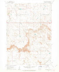
1961 Map of Cottonwood SE
USGS Topo · Published 1963About this map
Washburn Ridge stands as a prominent elevation in this Jackson County landscape, overlooking the drainages of Big Buffalo Creek and Fifteen Creek. The 1961 field check captures a western South Dakota ranching environment defined by numerous small water management features, including Arke Dam, Martin Dam, McHenry Dam, and Dobs Dam. These artificial impoundments suggest the critical importance of water conservation for livestock in the semi-arid terrain of the Big Buffalo and Little Buffalo regions.
Find a feature on this map
15 named features on this map. Tap any name to fly to it.
Don’t see what you’re looking for? This feature index may not catch every label — zoom into the map to look around manually.
Map Details
Editions of this 1961 Cottonwood SE Map
2 editions found
Other maps of this area

1950 · Interior
USGS Topo · 1:24,000

1950 · Weta
USGS Topo · 1:24,000

1951 · Wanblee NW
USGS Topo · 1:24,000

1951 · School Section Butte
USGS Topo · 1:24,000

1953 · Philip Junction
USGS Topo · 1:24,000

1955 · Martin
USGS Topo · 1:250,000

1958 · Martin
USGS Topo · 1:250,000

1960 · Cottonwood SW
USGS Topo · 1:24,000

1961 · Cottonwood
USGS Topo · 1:24,000

1961 · Cottonwood NE
USGS Topo · 1:24,000