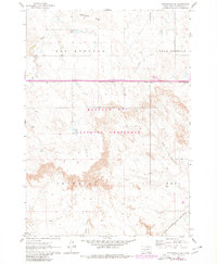
1961 Map of Cottonwood SE
USGS Topo · Published 1980About this map
Buffalo Gap National Grassland dominates this section of the western South Dakota plains, showing a landscape defined by expansive drainage systems and high ridges during the early 1960s. The map illustrates the varied topography between Washburn Ridge and the Interior and Weta regions, where the land is carved by Big Buffalo Creek, Fifteen Creek, and Cut Creek. Human intervention in this arid environment is evident through small-scale water management features like Arke Dam and Martin Dam. Transportation through the grasslands is anchored by the Chicago Milwaukee St Paul and Pacific railroad line, which skirts the southern edge of the survey area. A modern interstate-era Rest Area appears as a later revision, contrasting with the older network of trails and jeep tracks that crisscross the rugged badlands terrain.
Find a feature on this map
16 named features on this map. Tap any name to fly to it.
Don’t see what you’re looking for? This feature index may not catch every label — zoom into the map to look around manually.
Map Details
Editions of this 1961 Cottonwood SE Map
2 editions found
Other maps of this area

1950 · Interior
USGS Topo · 1:24,000

1950 · Weta
USGS Topo · 1:24,000

1951 · Wanblee NW
USGS Topo · 1:24,000

1951 · School Section Butte
USGS Topo · 1:24,000

1953 · Philip Junction
USGS Topo · 1:24,000

1955 · Martin
USGS Topo · 1:250,000

1958 · Martin
USGS Topo · 1:250,000

1960 · Cottonwood SW
USGS Topo · 1:24,000

1961 · Cottonwood
USGS Topo · 1:24,000

1961 · Cottonwood NE
USGS Topo · 1:24,000