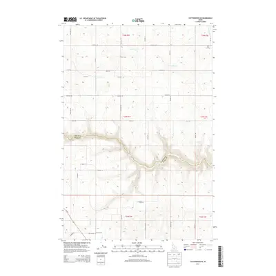
2013 Map of Cottonwood NE
USGS Topo · Published 2013About this map
Lawyer Cr carves a deep path across this landscape, defining the physical and political boundary between Lewis and Idaho counties. The 2013 topography reveals a rural environment structured by a grid of named roads like Evergreen Rd and Jacobs Rd, reflecting decades of land division and agricultural settlement. The interior of the quadrangle is marked by small locales and landmarks, such as Harris Siding and Christmans, which speak to the historical transit and social nodes of this high-country region. Researchers interested in family history will find the Holy Trinity Cem and Meadow Creek Cem clearly positioned. While Us-95 N skirts the southwestern corner, the majority of the area is shaped by the drainages of Meadow Cr and Long Hollow Cr, where the terrain dictates the winding paths of local routes like Swamp Rd and Canyon Rd.
Find a feature on this map
37 named features on this map. Tap any name to fly to it.
Don’t see what you’re looking for? This feature index may not catch every label — zoom into the map to look around manually.
Map Details
Editions of this 2013 Cottonwood NE Map
This is the sole edition of this map. No revisions or reprints were ever made.
Other maps of this area

1924 · Kamiah
USGS Topo · 1:125,000

1955 · Pullman
USGS Topo · 1:250,000

1958 · Pullman
USGS Topo · 1:250,000

1967 · Mohler
USGS Topo · 1:24,000

1967 · Fletcher
USGS Topo · 1:24,000

1967 · Craigmont
USGS Topo · 1:24,000
1967 · Nezperce SW
USGS Topo · 1:24,000

1967 · Sixmile Creek
USGS Topo · 1:24,000
1967 · Keuterville
USGS Topo · 1:24,000

1967 · Cottonwood NE
USGS Topo · 1:24,000