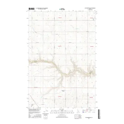
2017 Map of Cottonwood NE
USGS Topo · Published 2017About this map
Lawyer Cr carves a deep, sinuous path across this landscape, marking a clear physical and jurisdictional divide between Lewis and Idaho counties. The plateau terrain is defined by a systematic grid of rural roads, many bearing family names that suggest a long history of local land ownership. Significant watercourses like Meadow Cr and Long Hollow Cr drain the high country, creating the complex contour patterns that dominate the central and southern portions of the survey. Cultural landmarks are centered on sacred ground, specifically Holy Trinity Cem in the northeast and Meadow Creek Cem further south. The transportation network, including routes like Windy Ridge Rd and Meadow Creek Rd, follows the natural ridges and valleys, illustrating how the geography of the Camas Prairie region dictated settlement and movement well into the 21st century.
Find a feature on this map
34 named features on this map. Tap any name to fly to it.
Don’t see what you’re looking for? This feature index may not catch every label — zoom into the map to look around manually.
Map Details
Editions of this 2017 Cottonwood NE Map
This is the sole edition of this map. No revisions or reprints were ever made.
Other maps of this area

1924 · Kamiah
USGS Topo · 1:125,000

1955 · Pullman
USGS Topo · 1:250,000

1958 · Pullman
USGS Topo · 1:250,000

1967 · Mohler
USGS Topo · 1:24,000

1967 · Fletcher
USGS Topo · 1:24,000

1967 · Craigmont
USGS Topo · 1:24,000
1967 · Nezperce SW
USGS Topo · 1:24,000

1967 · Sixmile Creek
USGS Topo · 1:24,000
1967 · Keuterville
USGS Topo · 1:24,000

1967 · Cottonwood NE
USGS Topo · 1:24,000