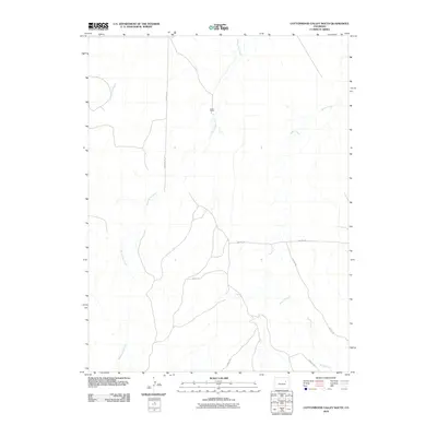
2010 Map of Cottonwood Valley South
USGS Topo · Published 2010About this map
Cross J Ranch sits amidst a network of intermittent watercourses in this high plains landscape at the start of the 21st century. The terrain is defined by the drainage patterns of Cottonwood Creek, Rattlesnake Creek, and Beaver Creek, which carve subtle paths through the territory. This 2010 survey highlights a sparse but organized infrastructure of rural routes, including Four Mile Rd and Wardel Rd, which serve the agricultural and ranching interests of the region. The map reveals the persistence of traditional land use and the layout of local travel ways like Hilltop Rd and Rocky Rd, providing a clear view of the area's development before further modern expansion. The presence of named ranches and specific road alignments offers valuable data for those tracing local land ownership and the evolution of rural Arapahoe County infrastructure.
Find a feature on this map
10 named features on this map. Tap any name to fly to it.
Don’t see what you’re looking for? This feature index may not catch every label — zoom into the map to look around manually.
Map Details
Editions of this 2010 Cottonwood Valley South Map
This is the sole edition of this map. No revisions or reprints were ever made.
Other maps of this area

1891 · Limon
USGS Topo · 1:125,000

1892 · Limon
USGS Topo · 1:125,000

1954 · Limon
USGS Topo · 1:250,000

1957 · Limon
USGS Topo · 1:250,000

1958 · Limon
USGS Topo · 1:250,000
1969 · Noonen Reservoir SW
USGS Topo · 1:24,000
1969 · Noonen Reservoir
USGS Topo · 1:24,000

1970 · Agate
USGS Topo · 1:24,000
1970 · Barking Dog Spring
USGS Topo · 1:24,000

1970 · T Draw
USGS Topo · 1:24,000