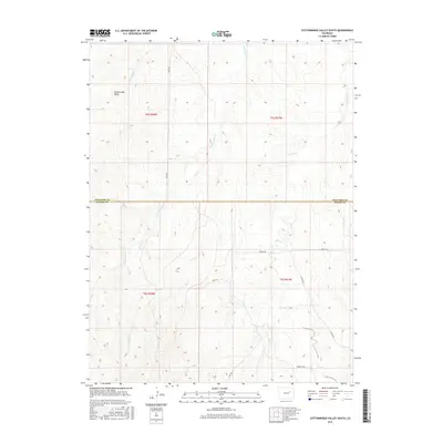
2016 Map of Cottonwood Valley South
USGS Topo · Published 2016About this map
Cottonwood Valley defines the northern reaches of this High Plains landscape where Arapahoe and Elbert counties meet. The drainage patterns of the region are clearly delineated by the paths of Cottonwood Cr, Rattlesnake Cr, and Beaver Cr, which carve through the undulating terrain. A systematic network of rural roads, including the precisely named 4 Mile Rd and the descriptive Hilltop Rd, Rocky Rd, and Ridge Rd, provides a framework for understanding the 21st-century land use in this part of Colorado. This U.S. Geological Survey topographic study documents the exact elevation contours and property boundaries, such as the Arapahoe Co Elbert Co line, providing an essential record of the area's geography and infrastructure as it existed in 2016.
Find a feature on this map
15 named features on this map. Tap any name to fly to it.
Don’t see what you’re looking for? This feature index may not catch every label — zoom into the map to look around manually.
Map Details
Editions of this 2016 Cottonwood Valley South Map
This is the sole edition of this map. No revisions or reprints were ever made.
Other maps of this area

1891 · Limon
USGS Topo · 1:125,000

1892 · Limon
USGS Topo · 1:125,000

1954 · Limon
USGS Topo · 1:250,000

1957 · Limon
USGS Topo · 1:250,000

1958 · Limon
USGS Topo · 1:250,000
1969 · Noonen Reservoir SW
USGS Topo · 1:24,000
1969 · Noonen Reservoir
USGS Topo · 1:24,000

1970 · Agate
USGS Topo · 1:24,000
1970 · Barking Dog Spring
USGS Topo · 1:24,000

1970 · T Draw
USGS Topo · 1:24,000