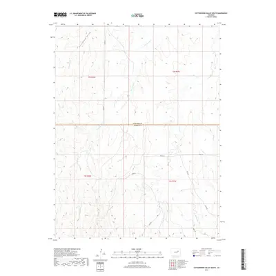
2019 Map of Cottonwood Valley South
USGS Topo · Published 2019About this map
Cottonwood Valley sits at the heart of this high-plains landscape, where the seasonal drainage of Cottonwood Cr and Rattlesnake Cr carves subtle relief into the terrain along the border of Arapahoe and Elbert counties. The map captures a section of the Colorado plains defined by a sparse but essential road network that follows the section lines and natural contours of the land, including 4 Mile Rd and Hilltop Rd. To the east, the drainage of Beaver Cr further defines the watershed, reflecting the open, ranch-oriented geography characteristic of this region. This survey serves as a clear record of the area's rural transition, showing the exact placement of dirt and local roads such as Jolly Rd, Wardel Rd, and Rocky Rd before more intensive development reaches these reaches of the eastern plains.
Find a feature on this map
16 named features on this map. Tap any name to fly to it.
Don’t see what you’re looking for? This feature index may not catch every label — zoom into the map to look around manually.
Map Details
Editions of this 2019 Cottonwood Valley South Map
This is the sole edition of this map. No revisions or reprints were ever made.
Other maps of this area

1891 · Limon
USGS Topo · 1:125,000

1892 · Limon
USGS Topo · 1:125,000

1954 · Limon
USGS Topo · 1:250,000

1957 · Limon
USGS Topo · 1:250,000

1958 · Limon
USGS Topo · 1:250,000
1969 · Noonen Reservoir SW
USGS Topo · 1:24,000
1969 · Noonen Reservoir
USGS Topo · 1:24,000

1970 · Agate
USGS Topo · 1:24,000
1970 · Barking Dog Spring
USGS Topo · 1:24,000

1970 · T Draw
USGS Topo · 1:24,000