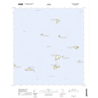
2024 Map of Cottrell Key
USGS Topo · Published 2024About this map
The Key West National Wildlife Refuge encompasses a scattering of mangrove islands and shallow banks where the Gulf of Mexico meets the Atlantic Ocean. This maritime landscape is defined by the Florida Keys Wilderness, protecting a chain of isolated landforms including Cottrell Key to the north and the larger clusters of Man Key and Woman Key to the south. Navigational markers like the Northwest Channel and the Intracoastal Waterway skirt the eastern edge of the quadrangle, while the southern reaches drop into the deep Straits of Florida. The presence of named features like Ballast Key and Joe Ingram Key highlights the specific island geography that has historically served as vital habitat and a challenge for mariners navigating the West Channel and Lakes Passage.
Find a feature on this map
21 named features on this map. Tap any name to fly to it.
Don’t see what you’re looking for? This feature index may not catch every label — zoom into the map to look around manually.
Map Details
Editions of this 2024 Cottrell Key Map
This is the sole edition of this map. No revisions or reprints were ever made.
Other maps of this area

1921 · Key West
USGS Topo · 1:62,500

1943 · Bay Keys
USGS Topo · 1:24,000

1943 · Key West
USGS Topo · 1:24,000

1943 · Cottrell Key
USGS Topo · 1:24,000

1962 · Key West
USGS Topo · 1:24,000

1963 · Cottrell Key
USGS Topo · 1:24,000

1971 · Key West
USGS Topo · 1:24,000
1971 · Marquesas Keys East
USGS Topo · 1:24,000
1972 · Cottrell Key
USGS Topo · 1:24,000
1972 · Bay Keys
USGS Topo · 1:24,000