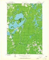
1944 Map of Couderay
USGS Topo · Published 1965About this map
The Lac Court Oreilles Indian Reservation dominates this mid-century landscape, defined by a massive complex of glacial lakes and northern forests. Major water bodies like Grindstone Lake, Court Oreilles Lake, and Whitefish Lake are central to the region's character, supporting early lakeside developments such as The Northwoods Beach. The map details the local infrastructure of the 1940s, including small rural education centers like Kinnamon Sch and Boylan Sch, alongside religious landmarks like Sacred Heart Ch and Whitefish Ch.
Find a feature on this map
80 named features on this map. Tap any name to fly to it.
Don’t see what you’re looking for? This feature index may not catch every label — zoom into the map to look around manually.
Map Details
Editions of this 1944 Couderay Map
2 editions found
Other maps of this area

1943 · Namekagon Lake
USGS Topo · 1:48,000

1944 · Exeland
USGS Topo · 1:48,000

1944 · Couderay
USGS Topo · 1:48,000

1944 · Radisson
USGS Topo · 1:48,000

1944 · Hayward
USGS Topo · 1:48,000

1945 · Namekagon Lake
USGS Topo · 1:48,000

1945 · Meteor
USGS Topo · 1:48,000

1947 · Exeland
USGS Topo · 1:48,000

1947 · Chittamo
USGS Topo · 1:48,000

1948 · Couderay
USGS Topo · 1:48,000