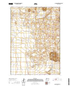
2020 Map of Cougar Mountain
USGS Topo · Published 2020About this map
Cougar Mtn dominates the eastern portion of this high desert terrain in northern Lake County, rising sharply above the expansive Fort Rock Valley. The landscape is defined by its volcanic topography, featuring numerous small volcanic buttes and depressions that typify the Great Basin province. Toward the southwest, the grid of Fort Rock Valley begins to transition from open volcanic flats into a more structured agricultural or residential pattern, indicated by the development of local thoroughfares such as Webster Rd, Soto Rd, and Soto W. This 2020 survey reveals how the vast, arid interior of Oregon continues to be organized by the Public Land Survey System, with township and range lines like t24s r15e and t25s r15e segmenting the landscape into manageable tracts for ranching and land management.
Find a feature on this map
10 named features on this map. Tap any name to fly to it.
Don’t see what you’re looking for? This feature index may not catch every label — zoom into the map to look around manually.
Map Details
Editions of this 2020 Cougar Mountain Map
This is the sole edition of this map. No revisions or reprints were ever made.
Other maps of this area

1931 · Newberry Crater
USGS Topo · 1:125,000

1935 · Newberry Crater
USGS Topo · 1:125,000

1955 · Crescent
USGS Topo · 1:250,000

1957 · Crescent
USGS Topo · 1:250,000

1958 · Crescent
USGS Topo · 1:250,000

1970 · Crescent
USGS Topo · 1:250,000

1979 · Crescent
USGS Topo · 1:100,000

1981 · Fox Butte
USGS Topo · 1:24,000

1981 · Hogback Butte
USGS Topo · 1:24,000

1981 · Cougar Mtn
USGS Topo · 1:24,000