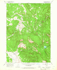
1964 Map of Cougar Peak
USGS Topo · Published 1966About this map
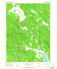
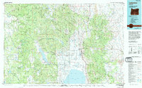
Fremont National Forest dominates this mid-1960s landscape, where the high-altitude terrain is marked by distinctive flats and named ridges. Cattle ranching and early infrastructure are evident at the Drews Valley Ranch along the edge of the Drews Valley, while the interior of the forest contains historical markers like Lucky Camp and the winding Old Railroad Grade. The network of springs, including Mcclendon Spring and Hilario Spring, suggests a landscape vital for both local livestock and forest management. High points such as Cougar Peak, with its lookout, and Grizzly Peak provide vantage points over the complex drainage systems of Cottonwood Creek and Chandler Creek. The inclusion of the Cougar Creek Campground and Beaver Dam Picnic Ground reflects the post-war expansion of recreational access into these Oregon highlands, providing a snapshot of the region before modern development.
Find a feature on this map
35 named features on this map. Tap any name to fly to it.
Don’t see what you’re looking for? This feature index may not catch every label — zoom into the map to look around manually.
Map Details
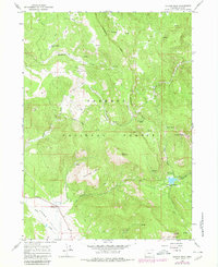
Editions of this 1964 Cougar Peak Map
2 editions found
Other maps of this area

1955 · Klamath Falls
USGS Topo · 1:250,000

1958 · Klamath Falls
USGS Topo · 1:250,000
1960 · Strawberry Butte
USGS Topo · 1:62,500
1960 · Fishhole Mtn
USGS Topo · 1:62,500

1964 · Drews Reservoir
USGS Topo · 1:24,000
1964 · Cox Flat
USGS Topo · 1:24,000
1964 · Coleman Point
USGS Topo · 1:24,000
1964 · Shoestring Butte
USGS Topo · 1:24,000
1964 · Drews Gap
USGS Topo · 1:24,000
1975 · Lakeview
USGS Topo · 1:100,000