
1964 Map of Drews Reservoir
USGS Topo · Published 1965About this map
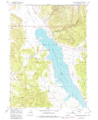
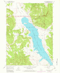
Drews Reservoir dominates the center of this 1964 survey, showing the water level at its spillway elevation 4915. The landscape is a high-altitude mix of the Fremont National Forest and the broad flats of Drews Valley to the northwest. Ranching and land management are evident through labels for the Hay Creek Ranch and numerous scattered springs such as Kernan Spring and Dip Spring, which served as vital water sources for livestock. The map records a network of early backcountry access, including the Salt Springs Road and various jeep trails like the La Sere Trail. To the east, the Willow Creek Hills rise above the shoreline, while the northern reaches are fed by Drews Creek and Chandler Creek. This topographical record captures the area just after photogrammetric methods from 1960 were field-checked in 1964.
Find a feature on this map
24 named features on this map. Tap any name to fly to it.
Don’t see what you’re looking for? This feature index may not catch every label — zoom into the map to look around manually.
Map Details
Editions of this 1964 Drews Reservoir Map
3 editions found
Other maps of this area

1955 · Klamath Falls
USGS Topo · 1:250,000

1958 · Klamath Falls
USGS Topo · 1:250,000

1960 · Strawberry Butte
USGS Topo · 1:62,500

1960 · Fishhole Mtn
USGS Topo · 1:62,500

1964 · Cox Flat
USGS Topo · 1:24,000
1964 · Dog Lake
USGS Topo · 1:24,000

1964 · Cougar Peak
USGS Topo · 1:24,000
1964 · Fitzwater Point
USGS Topo · 1:24,000

1964 · Drews Gap
USGS Topo · 1:24,000

1975 · Lakeview
USGS Topo · 1:100,000