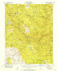
1947 Map of Coulterville
USGS Topo · Published 1953About this map
The gold-bearing quartz veins of California's Mother Lode dominate this 1947 field-checked study, centering on the historic mining hub of Coulterville. This landscape is densely populated with hard-rock mining sites such as the Mary Harrison Mine, Virginia Mine, and the Mountain King Mine along the Merced River. The map illustrates the transition from the rugged mining camps of the mid-19th century toward more established agricultural and civic life, evidenced by the Greeley Hill School and Quartzburg School.
Find a feature on this map
111 named features on this map. Tap any name to fly to it.
Don’t see what you’re looking for? This feature index may not catch every label — zoom into the map to look around manually.
Map Details
Editions of this 1947 Coulterville Map
4 editions found

Other maps of this area

1893 · Sonora
USGS Topo · 1:125,000

1896 · Sonora
USGS Topo · 1:125,000

1897 · Sonora
USGS Topo · 1:125,000

1897 · Yosemite
USGS Topo · 1:125,000

1898 · Sonora
USGS Topo · 1:125,000

1900 · Yosemite
USGS Topo · 1:125,000

1903 · Yosemite
USGS Topo · 1:125,000

1909 · Yosemite
USGS Topo · 1:125,000

1912 · Mariposa
USGS Topo · 1:125,000

1916 · Merced Falls
USGS Topo · 1:24,000