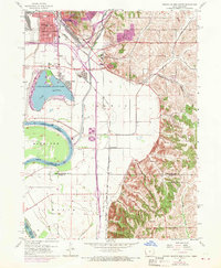
1956 Map of Council Bluffs South
USGS Topo · Published 1970About this map
The southern outskirts of Council Bluffs reveal a mid-century landscape defined by the winding Missouri River and the significant recreational anchor of Lake Manawa State Park. This 1956 survey, updated with 1969 revisions, captures the complex rail infrastructure where lines like the Norfolk and Western and Chicago and North Western converge near the Iowa-Nebraska border. Beyond the growing urban grid of the city, the map transitions into the bluffs and bottoms of Pottawattamie and Mills counties.
Find a feature on this map
27 named features on this map. Tap any name to fly to it.
Don’t see what you’re looking for? This feature index may not catch every label — zoom into the map to look around manually.
Map Details
Editions of this 1956 Council Bluffs South Map
3 editions found
Other maps of this area

1893 · Omaha
USGS Topo · 1:62,500

1954 · Omaha
USGS Topo · 1:250,000

1956 · Glenwood
USGS Topo · 1:24,000

1956 · Mineola
USGS Topo · 1:24,000

1956 · Plattsmouth
USGS Topo · 1:24,000

1956 · Council Bluffs North
USGS Topo · 1:24,000

1956 · Pacific Junction
USGS Topo · 1:24,000

1956 · Omaha North
USGS Topo · 1:24,000

1956 · Mc Clelland
USGS Topo · 1:24,000

1956 · Council Bluffs South
USGS Topo · 1:24,000