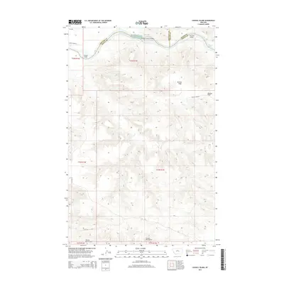
2014 Map of Council Island
USGS Topo · Published 2014About this map
The Missouri River cuts through this northern Montana landscape, marking the tri-county meeting point of Chouteau, Fergus, and Blaine counties. The river's path is defined by a series of significant mid-stream features, including the prominent Council Island, the Holmes Council Islands, and the Iron City Islands. Navigational hazards such as Holmes Rapids and McKeever Rapids indicate the river's character in this stretch, where the water has shaped a complex system of islands and sandbars. South of the river, the elevation rises toward Whiskey Ridge, a dominant upland feature flanked by Dog Cr. This terrain is dissected by deep drainage patterns like Seventy Nine Coulee, illustrating the erosive power of seasonal runoff in this high-plains environment. A sparse network of tracks, including Whiskey Ridge Rd and W 79 Trl, provides the only access through this expansive ranching and river territory.
Find a feature on this map
17 named features on this map. Tap any name to fly to it.
Don’t see what you’re looking for? This feature index may not catch every label — zoom into the map to look around manually.
Map Details
Editions of this 2014 Council Island Map
This is the sole edition of this map. No revisions or reprints were ever made.
Other maps of this area

1954 · P N Ranch
USGS Topo · 1:24,000

1954 · Gallatin Rapids
USGS Topo · 1:24,000

1954 · Council Island
USGS Topo · 1:24,000

1954 · Lewistown
USGS Topo · 1:250,000

1959 · Lewistown
USGS Topo · 1:250,000

1964 · Wolf Creek Falls
USGS Topo · 1:24,000

1964 · Pigtail Coulee
USGS Topo · 1:24,000

1964 · Anderson Bridge
USGS Topo · 1:24,000

1964 · Ragland Bench
USGS Topo · 1:24,000

1964 · Chase Hill
USGS Topo · 1:24,000