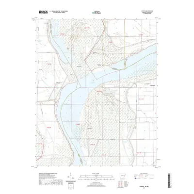
2020 Map of Council
USGS Topo · Published 2020About this map
The Mississippi River carves a complex path through the Delta on this map, defining the boundary between Lee County, Arkansas, and Tunica County, Mississippi. The river's historical shifts have left a legacy of oxbows and islands, including Council Island, Peters Island, and Rabbit Island. Local settlements such as Council and Peters are situated behind the protection of the Mississippi River Levee, while topographic features like Commerce Cut Off and Council Bend indicate the dynamic nature of the river channel. Genealogists may find value in the location of the Peters Cem and Happy Cem. The landscape is dominated by river-adjacent terrain such as Campbell Bar and Basket Bar, while water bodies like Midway Lake and Old River Lake reflect the remnants of former river paths. Modern development is visible along the Mississippi side with Casino Strip Resort Blvd and Isle of Capri Blvd.
Find a feature on this map
48 named features on this map. Tap any name to fly to it.
Don’t see what you’re looking for? This feature index may not catch every label — zoom into the map to look around manually.
Map Details
Editions of this 2020 Council Map
This is the sole edition of this map. No revisions or reprints were ever made.
Other maps of this area

1908 · Hollywood
USGS Topo · 1:24,000

1913 · Hollywood
USGS Topo · 1:31,680

1931 · Horseshoe Lake
USGS Topo · 1:62,500

1939 · Clayton
USGS Topo · 1:62,500

1939 · Horseshoe Lake
USGS Topo · 1:62,500

1939 · Park Place
USGS Topo · 1:62,500

1939 · Latour
USGS Topo · 1:62,500

1948 · Helena
USGS Topo · 1:250,000

1950 · Helena
USGS Topo · 1:250,000

1954 · Horseshoe Lake
USGS Topo · 1:62,500