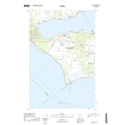
2020 Map of Coupeville
USGS Topo · Published 2020About this map
Coupeville sits at the heart of Whidbey Island, anchored by its historic connection to the protected waters of Penn Cove. This landscape is defined by the expansive Ebey's Landing National Historical Reserve, a rare site that preserves the long-standing agricultural patterns of the Pacific Northwest. The map shows the fertile stretches of Smith Prairie and Ebeys Prairie, where early farmsteads were established around settlements like Prairie Center and San de Fuca. Notable heritage sites such as Sunnyside Cem and Admiralty Head reflect the area’s deep 19th-century roots. Moving south, the terrain transitions from the harbor at Keystone Harbor to the long, narrow Keystone Spit and the wetlands of Crockett Lake. Military history is also present through the Coupeville Naval Outlying Field, illustrating the ongoing strategic importance of this location at the entrance to Puget Sound and Admiralty Inlet.
Find a feature on this map
66 named features on this map. Tap any name to fly to it.
Don’t see what you’re looking for? This feature index may not catch every label — zoom into the map to look around manually.
Map Details
Editions of this 2020 Coupeville Map
This is the sole edition of this map. No revisions or reprints were ever made.
Other maps of this area

1939 · Port Townsend
USGS Topo · 1:62,500

1939 · Coupeville
USGS Topo · 1:62,500

1943 · Richardson
USGS Topo · 1:62,500

1943 · Deception Pass
USGS Topo · 1:62,500

1951 · Deception Pass
USGS Topo · 1:62,500

1953 · Coupeville
USGS Topo · 1:24,000

1953 · Freeland
USGS Topo · 1:24,000

1953 · Nordland
USGS Topo · 1:24,000

1953 · Camano
USGS Topo · 1:24,000

1953 · Port Townsend North
USGS Topo · 1:24,000