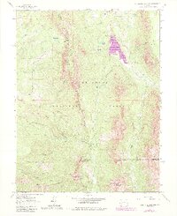
1983 Map of Courthouse Mountain
USGS Topo · Published 1984About this map
Cimarron Ridge forms a massive vertical spine through this portion of the Uncompahgre National Forest, dividing the drainage basins of the Cimarron River forks. This 1983 revision captures the high-altitude landscape of the San Juan Mountains during a period of transition, reflecting both the legacy of extraction at the Kennedy Mine and the shift toward modern conservation and water management. The Silver Jack Reservoir dominates the eastern half of the sheet, fed by the West Fork Cimarron River. Significant geological landmarks such as Chimney Rock and the high summits of Courthouse Mountain and Dunsinane Mountain define the southern boundary where the forest gives way to the Big Blue Wilderness. A complex network of trails, pack trails, and jeep trails provides the only access into these steep basins, including routes over Owl Creek Pass and Lou Creek Pass.
Find a feature on this map
45 named features on this map. Tap any name to fly to it.
Don’t see what you’re looking for? This feature index may not catch every label — zoom into the map to look around manually.
Map Details
Editions of this 1983 Courthouse Mountain Map
This is the sole edition of this map. No revisions or reprints were ever made.
Other maps of this area

1902 · Ouray
USGS Topo · 1:62,500

1903 · Lake City
USGS Topo · 1:62,500

1904 · Ouray
USGS Topo · 1:62,500

1905 · Lake City
USGS Topo · 1:62,500

1908 · Uncompahgre
USGS Topo · 1:125,000

1909 · Montrose
USGS Topo · 1:125,000

1911 · Uncompahgre
USGS Topo · 1:125,000

1911 · Montrose
USGS Topo · 1:125,000

1955 · Ouray
USGS Topo · 1:24,000

1956 · Montrose
USGS Topo · 1:250,000