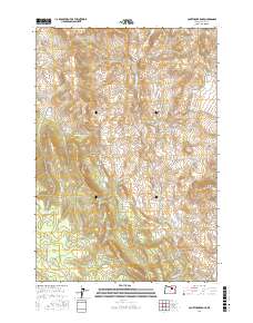
2017 Map of Courthouse Rock
USGS Topo · Published 2017About this map
Courthouse Rock rises prominently in this high-elevation landscape of Grant County, where the terrain is marked by steep ridges and seasonal drainages. The area is defined by its network of springs, including Scribners Spring, Levi Spring, and Meteer Spring, which likely served as vital water sources for early cattle and sheep ranching in this part of Oregon.
Find a feature on this map
31 named features on this map. Tap any name to fly to it.
Don’t see what you’re looking for? This feature index may not catch every label — zoom into the map to look around manually.
Map Details
Editions of this 2017 Courthouse Rock Map
This is the sole edition of this map. No revisions or reprints were ever made.
Other maps of this area

1951 · Courtrock
USGS Topo · 1:62,500

1951 · Monument
USGS Topo · 1:62,500

1953 · Kimberly
USGS Topo · 1:62,500

1953 · Picture
USGS Topo · 1:62,500

1955 · Canyon City
USGS Topo · 1:250,000

1959 · Canyon City
USGS Topo · 1:250,000

1980 · Monument
USGS Topo · 1:100,000
1990 · Donaldson Creek
USGS Topo · 1:24,000
1990 · Monument
USGS Topo · 1:24,000
1990 · Miller Flat
USGS Topo · 1:24,000