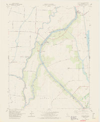
1978 Map of Courtland
USGS Topo · Published 1978About this map
Sacramento River frontage and the complex irrigation systems of the California Delta define this landscape during the late 1970s. The map illustrates a highly productive agricultural region where land use is dictated by a network of waterways including Elk Slough, Sutter Slough, and Steamboat Slough. These sloughs encircle massive island tracts such as Merritt Island and Grand Island, where numerous pumping stations and gas wells are situated. The settlement of Courtland serves as a primary hub, supported by the Bates Union Sch and historically significant river access points like Morgans Landing and Paintersville. To the east, the Southern Pacific railroad corridor runs parallel to the river, passing through the historic community of Locke and near Hood. This survey reflects the intersection of maritime transport legacy and modern levee management essential to the region's deltaic economy.
Find a feature on this map
51 named features on this map. Tap any name to fly to it.
Don’t see what you’re looking for? This feature index may not catch every label — zoom into the map to look around manually.
Map Details
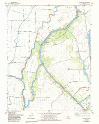
Editions of this 1978 Courtland Map
3 editions found

Other maps of this area

1894 · Lodi
USGS Topo · 1:125,000

1908 · Courtland
USGS Topo · 1:62,500

1909 · Florin
USGS Topo · 1:31,680

1910 · New Hope
USGS Topo · 1:31,680

1910 · Rio Vista
USGS Topo · 1:31,680

1910 · Bruceville
USGS Topo · 1:31,680

1910 · Isleton
USGS Topo · 1:31,680

1916 · Cache Slough
USGS Topo · 1:31,680

1916 · Vorden
USGS Topo · 1:31,680
1916 · Babel Slough
USGS Topo · 1:31,680