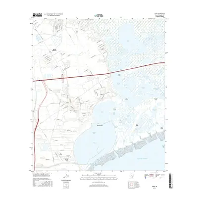
2016 Map of Cove
USGS Topo · Published 2016About this map
Cotton Lake and the complex tidal landscape of the Trinity River delta dominate this 2016 survey of coastal Chambers County. The map captures a transition zone between the developing outskirts of Mont Belvieu and the marshy expanses of the Gulf of Mexico shoreline. A dense network of bayous and ponds, such as Alligator Bayou, High Tree Bayou, and Cane Pond, illustrates the intricate hydrology of the upper Galveston Bay area. For genealogists and local historians, several family-named landmarks and small burial grounds are documented, including the Tilton Cem, Icet Cem, and Winfree Cem. Aviation history is also represented by the proximity of Slack Airport and RWJ Airpark, while the industrial footprint is marked by the Cedar Bayou Generating Station near Beach City.
Find a feature on this map
120 named features on this map. Tap any name to fly to it.
Don’t see what you’re looking for? This feature index may not catch every label — zoom into the map to look around manually.
Map Details
Editions of this 2016 Cove Map
This is the sole edition of this map. No revisions or reprints were ever made.
Other maps of this area

1916 · Morgan Point
USGS Topo · 1:24,000

1916 · Cedar Bayou
USGS Topo · 1:24,000

1919 · Morgan Point
USGS Topo · 1:31,680

1919 · Cedar Bayou
USGS Topo · 1:31,680

1942 · Anahuac
USGS Topo · 1:24,000

1943 · West of Eagle
USGS Topo · 1:31,680
1943 · Morgan Point
USGS Topo · 1:31,680

1943 · Cedar Bayou
USGS Topo · 1:24,000

1950 · Houston
USGS Topo · 1:250,000
1956 · Morgan Point
USGS Topo · 1:24,000