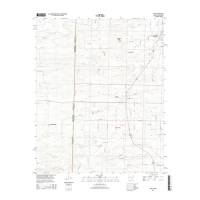
2014 Map of Cove
USGS Topo · Published 2014About this map
The Oklahoma-Arkansas border cuts vertically through this terrain, dividing McCurtain County from Polk County. The landscape is defined by the numerous drainage networks flowing into the Mountain Fork and Buffalo Creek, which carve through the elevations of the Ouachita region. In the eastern portion of the map, the small settlements of Hatfield and Cove serve as primary hubs of activity, connected by a network of rural roads such as Polk 26 Road and Polk 22 Road. Smaller localities like Plunketville and Pleasant Hill appear alongside essential community landmarks. Local history is deeply embedded in the land, evidenced by several family and community burial grounds including Buffalo Cemetery, Westview Cemetery, and the Cecil Chapel Cemetery, which provide vital touchstones for genealogical research in this borderland territory.
Find a feature on this map
40 named features on this map. Tap any name to fly to it.
Don’t see what you’re looking for? This feature index may not catch every label — zoom into the map to look around manually.
Map Details
Editions of this 2014 Cove Map
This is the sole edition of this map. No revisions or reprints were ever made.
Other maps of this area
1890 · Poteau Mountain
USGS Topo · 1:125,000
1899 · Poteau Mountain
USGS Topo · 1:125,000
1900 · Winding Stair
USGS Topo · 1:125,000
1902 · Lukfata
USGS Topo · 1:125,000
1909 · Winding Stair
USGS Topo · 1:125,000
1913 · De Queen
USGS Topo · 1:125,000
1950 · Mcalester
USGS Topo · 1:250,000
1958 · Potter
USGS Topo · 1:62,500
1958 · Zafra
USGS Topo · 1:24,000
1958 · Potter
USGS Topo · 1:24,000