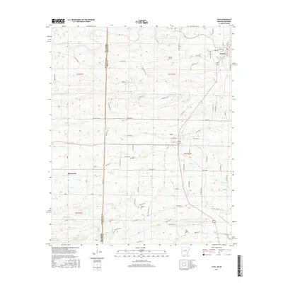
2017 Map of Cove
USGS Topo · Published 2017About this map
The Oklahoma Arkansas border defines the western edge of this Polk County landscape, where the Ouachita Mountains' topography shapes the local settlement pattern. The town of Hatfield anchors the northeast corner, while Cove and the smaller community of Plunketville lie further south, connected by a network of rural routes like Polk Road 24 and Polk Road 138. This 2017 survey reveals a deeply established rural culture, evidenced by numerous historical burying grounds including Buffalo Cem, Westview Cem, and Pleasant Hill Cem. The terrain is intricately carved by water, from the northern Mountain Fork to the southern reaches of Buffalo Creek and Hickory Cr. Genealogists will find the detailed naming of family-linked roads and small landmarks like Cecil Chapel Cem invaluable for placing 19th and 20th-century ancestors within specific township and range divisions such as t3s r32w.
Find a feature on this map
85 named features on this map. Tap any name to fly to it.
Don’t see what you’re looking for? This feature index may not catch every label — zoom into the map to look around manually.
Map Details
Editions of this 2017 Cove Map
This is the sole edition of this map. No revisions or reprints were ever made.
Other maps of this area

1890 · Poteau Mountain
USGS Topo · 1:125,000

1899 · Poteau Mountain
USGS Topo · 1:125,000

1900 · Winding Stair
USGS Topo · 1:125,000

1902 · Lukfata
USGS Topo · 1:125,000

1909 · Winding Stair
USGS Topo · 1:125,000

1913 · De Queen
USGS Topo · 1:125,000

1950 · Mcalester
USGS Topo · 1:250,000

1958 · Potter
USGS Topo · 1:62,500

1958 · Zafra
USGS Topo · 1:24,000
1958 · Potter
USGS Topo · 1:24,000