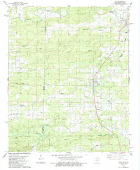
1984 Map of Cove
USGS Topo · Published 1985About this map
Cove and Hatfield serve as the primary population centers along the Kansas City Southern railroad line in the mid-1980s. This Ouachita Mountain landscape is defined by its transition across the Oklahoma Arkansas state line, specifically where McCurtain and Polk counties meet. The settlement pattern reflects a deeply rooted rural community, anchored by numerous country churches such as Midway Ch, Westview Ch, and Cecil Chapel.
Find a feature on this map
36 named features on this map. Tap any name to fly to it.
Don’t see what you’re looking for? This feature index may not catch every label — zoom into the map to look around manually.
Map Details
Editions of this 1984 Cove Map
This is the sole edition of this map. No revisions or reprints were ever made.
Other maps of this area

1890 · Poteau Mountain
USGS Topo · 1:125,000

1899 · Poteau Mountain
USGS Topo · 1:125,000

1900 · Winding Stair
USGS Topo · 1:125,000

1902 · Lukfata
USGS Topo · 1:125,000

1909 · Winding Stair
USGS Topo · 1:125,000

1913 · De Queen
USGS Topo · 1:125,000

1950 · Mcalester
USGS Topo · 1:250,000

1958 · Potter
USGS Topo · 1:62,500

1958 · Zafra
USGS Topo · 1:24,000
1958 · Potter
USGS Topo · 1:24,000