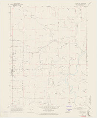
1967 Map of Covelo East
USGS Topo · Published 1969About this map
Round Valley serves as the dominant geographical feature of this Mendocino County landscape, where the town of Covelo sits at the western edge of a broad agricultural basin. The map illustrates a complex relationship between public and private lands, specifically defining the boundaries of the Indian Reservation alongside numerous private holdings. To the east, the terrain shifts abruptly from the flat valley floor into the steep, ridged geography of the Middle Fork Eel River canyon. Cultural landmarks like the Nome Lackee Cem and Yuki Cem provide important links to the local indigenous and pioneer history, while the presence of a Landing Strip and Ranger Station Community Center in the mid-1960s highlights the town's role as a regional hub for forest management and remote access. Drainage patterns including Williams Creek and Short Creek converge toward the valley, supporting the ranching and timber-based economy of the era.
Find a feature on this map
47 named features on this map. Tap any name to fly to it.
Don’t see what you’re looking for? This feature index may not catch every label — zoom into the map to look around manually.
Map Details
Editions of this 1967 Covelo East Map
3 editions found
Other maps of this area

1920 · Covelo
USGS Topo · 1:62,500

1926 · Covelo
USGS Topo · 1:62,500

1929 · Eden Valley
USGS Topo · 1:62,500

1951 · Laytonville
USGS Topo · 1:62,500

1952 · Spyrock
USGS Topo · 1:62,500

1952 · Eden Valley
USGS Topo · 1:62,500

1952 · Covelo
USGS Topo · 1:62,500

1957 · Ukiah
USGS Topo · 1:250,000

1960 · Ukiah
USGS Topo · 1:250,000
1966 · Leech Lake Mountain
USGS Topo · 1:24,000