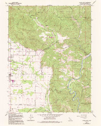
1967 Map of Covelo East
USGS Topo · Published 1994About this map
The Round Valley Indian Reservation occupies much of this landscape in eastern Mendocino County, where the valley floor transitions into steep ridges. The settlement of Covelo serves as a local hub, surrounded by agricultural infrastructure including a network of wells and irrigation channels. Cultural and historical landmarks are prevalent within the reservation boundary, notably the Nome Lackee Cem and Yuki Cem, as well as the Faith Tabernacle Community Ch. To the east, the topography becomes significantly more complex as the land rises toward Asa Bean Ridge and drops into the canyon of the Middle Fork Eel River. This 1967 survey, with revisions through the early 1990s, documents the intersection of tribal lands with natural water systems like Short Creek and Mill Creek, reflecting a community deeply tied to the drainage patterns of the Eel River watershed.
Find a feature on this map
37 named features on this map. Tap any name to fly to it.
Don’t see what you’re looking for? This feature index may not catch every label — zoom into the map to look around manually.
Map Details
Editions of this 1967 Covelo East Map
3 editions found
Other maps of this area

1920 · Covelo
USGS Topo · 1:62,500

1926 · Covelo
USGS Topo · 1:62,500

1929 · Eden Valley
USGS Topo · 1:62,500

1951 · Laytonville
USGS Topo · 1:62,500

1952 · Spyrock
USGS Topo · 1:62,500

1952 · Eden Valley
USGS Topo · 1:62,500

1952 · Covelo
USGS Topo · 1:62,500

1957 · Ukiah
USGS Topo · 1:250,000

1960 · Ukiah
USGS Topo · 1:250,000
1966 · Leech Lake Mountain
USGS Topo · 1:24,000