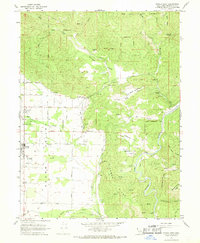
1967 Map of Covelo East
USGS Topo · Published 1969About this map
Round Valley serves as a distinct geographical bowl in the northern California interior, dominated by the Round Valley Indian Reservation and the town of Covelo. This mid-century survey reveals a landscape of ranching and remote settlement where family names define the local infrastructure, seen in routes like Fairbanks Lane, Hurt Road, and Hanson Lane. The area's cultural history is marked by sites such as Nome Lackee Cem and Yuki Cem, while the Middle Fork Eel River winds through the eastern ridges past Atkinson Flat and Etsel Flat. The western valley floor is dotted with numerous water wells and civic markers, including a Ranger Station and Landing Strip, illustrating a community deeply connected to its agricultural roots and the surrounding mountain ridges like Bluenose Ridge and Dingman Ridge.
Find a feature on this map
48 named features on this map. Tap any name to fly to it.
Don’t see what you’re looking for? This feature index may not catch every label — zoom into the map to look around manually.
Map Details
Editions of this 1967 Covelo East Map
3 editions found
Other maps of this area

1920 · Covelo
USGS Topo · 1:62,500

1926 · Covelo
USGS Topo · 1:62,500

1929 · Eden Valley
USGS Topo · 1:62,500

1951 · Laytonville
USGS Topo · 1:62,500

1952 · Spyrock
USGS Topo · 1:62,500

1952 · Eden Valley
USGS Topo · 1:62,500

1952 · Covelo
USGS Topo · 1:62,500

1957 · Ukiah
USGS Topo · 1:250,000

1960 · Ukiah
USGS Topo · 1:250,000
1966 · Leech Lake Mountain
USGS Topo · 1:24,000