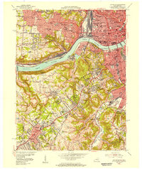
1955 Map of Covington
USGS Topo · Published 1957About this map
Cincinnati and Covington anchor this mid-century portrait of the sprawling riverfront urban core and its emerging post-war suburbs. The Ohio River and Licking River define the industrial and commercial heart, where major infrastructure like Union Sta and numerous railroads—including the Baltimore and Ohio RR and New York Central RR—coordinate the region's transport. Beyond the dense city centers, the landscape transitions into the hills of Northern Kentucky and Western Ohio, populated by numerous Catholic institutions such as Villa Madonna Academy, Notre Dame Convent, and St Johns Orphanage. These religious and educational landmarks, alongside expansive burial grounds like St Joseph Cemetery, reveal the deep-seated community foundations of neighborhoods from Price Hill and Sedamsville to Fort Mitchell and Erlanger.
Find a feature on this map
112 named features on this map. Tap any name to fly to it.
Don’t see what you’re looking for? This feature index may not catch every label — zoom into the map to look around manually.
Map Details
Editions of this 1955 Covington Map
This is the sole edition of this map. No revisions or reprints were ever made.
Other maps of this area

1898 · East Cincinnati
USGS Topo · 1:62,500

1914 · East Cincinnati
USGS Topo · 1:62,500

1914 · West Cincinnati
USGS Topo · 1:62,500

1929 · Alexandria
USGS Topo · 1:48,000

1936 · Alexandria
USGS Topo · 1:62,500

1950 · Union
USGS Topo · 1:24,000

1950 · Independence
USGS Topo · 1:24,000

1950 · Covington
USGS Topo · 1:24,000

1951 · Burlington
USGS Topo · 1:24,000

1952 · Newport
USGS Topo · 1:24,000