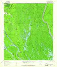
1953 Map of Cow Bayou
USGS Topo · Published 1960About this map
The Atchafalaya Floodway dominates this mid-century landscape on the border of St. Martin and Iberville Parishes. This is a region defined by complex hydrology and hydraulic engineering, where the Whisky Bay Pilot Channel and the East Protection Levee work to manage the vast deltaic drainage of the Atchafalaya River. The natural meandering of the Grand River and Upper Grand River contrasts with the straight lines of the levee systems, illustrating the 1950s-era efforts to control seasonal flooding. Interspersed among the dense network of water bodies like Billy Little Lake and Jim Lake are signs of industrial extraction, with several Oil Wells and Gas Wells appearing in the northern reaches. The terrain is a maze of bayous, including Bristow Bayou and Maringouin Bayou, which speak to the historic waterborne navigation and settlement patterns of the Louisiana basin.
Find a feature on this map
32 named features on this map. Tap any name to fly to it.
Don’t see what you’re looking for? This feature index may not catch every label — zoom into the map to look around manually.
Map Details
Editions of this 1953 Cow Bayou Map
2 editions found
Other maps of this area

1935 · Osca Bayou
USGS Topo · 1:62,500

1935 · Chicot Lake
USGS Topo · 1:62,500

1940 · Grosse Tete
USGS Topo · 1:62,500

1941 · Loreauville
USGS Topo · 1:62,500

1953 · Cow Bayou
USGS Topo · 1:24,000

1953 · Pigeon Bay
USGS Topo · 1:24,000

1953 · Maringouin
USGS Topo · 1:24,000

1953 · Grosse Tete SW
USGS Topo · 1:24,000

1954 · Chicot Lake
USGS Topo · 1:62,500

1954 · Loreauville
USGS Topo · 1:62,500