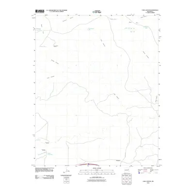
2010 Map of Cow Canyon
USGS Topo · Published 2010About this map
Mesa Rica dominates the northern landscape of this region, where the high desert terrain is deeply incised by a network of drainage systems. The settlement of Palomas sits near the southern edge, positioned where the Arroyo de las Palomas meets the surrounding plains. The map reveals a land defined by water management in an arid climate, marked by numerous named livestock tanks such as Cow Canyon Tank, Hondo Tank, and Kauffman Tank.
Find a feature on this map
22 named features on this map. Tap any name to fly to it.
Don’t see what you’re looking for? This feature index may not catch every label — zoom into the map to look around manually.
Map Details
Editions of this 2010 Cow Canyon Map
This is the sole edition of this map. No revisions or reprints were ever made.
Other maps of this area

1930 · Tucumcari
USGS Topo · 1:125,000

1954 · Santa Fe
USGS Topo · 1:250,000

1954 · Tucumcari
USGS Topo · 1:250,000

1958 · Santa Fe
USGS Topo · 1:250,000

1958 · Tucumcari
USGS Topo · 1:250,000

1964 · Muniz Canyon
USGS Topo · 1:24,000
1964 · Montoya
USGS Topo · 1:24,000

1967 · Trinchera Creek
USGS Topo · 1:24,000

1967 · Monument Point
USGS Topo · 1:24,000

1967 · Liberty Mesa
USGS Topo · 1:24,000