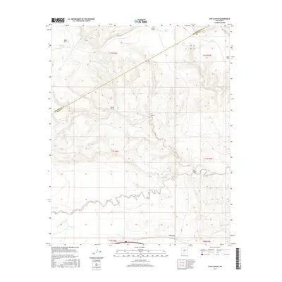
2017 Map of Cow Canyon
USGS Topo · Published 2017About this map
The small settlement of Palomas sits at the southern edge of this high-desert landscape, where the flat-topped Mesa Rica dominates the northern horizon. The terrain is defined by a series of dramatic incisions through the mesa and plateau, most notably Cow Canyon and Vigil Canyon, which feed into the meandering course of Pajarito Creek. This map captures a ranching environment where water management is critical; numerous livestock tanks such as Kauffman Tank, Primo Tank, and South Privo Tank are scattered across the township and range sections. The county line between San Miguel Co and Quay Co cuts diagonally across the northwestern corner, following a boundary that separates the rugged breaks of Hondo Canyon from the drainages of Johnson Cr. For local historians, the map preserves the specific locations of these named tanks and arroyos, such as Arroyo de las Palomas, reflecting decades of land use in this part of New Mexico.
Find a feature on this map
25 named features on this map. Tap any name to fly to it.
Don’t see what you’re looking for? This feature index may not catch every label — zoom into the map to look around manually.
Map Details
Editions of this 2017 Cow Canyon Map
This is the sole edition of this map. No revisions or reprints were ever made.
Other maps of this area

1930 · Tucumcari
USGS Topo · 1:125,000

1954 · Santa Fe
USGS Topo · 1:250,000

1954 · Tucumcari
USGS Topo · 1:250,000

1958 · Santa Fe
USGS Topo · 1:250,000

1958 · Tucumcari
USGS Topo · 1:250,000

1964 · Muniz Canyon
USGS Topo · 1:24,000
1964 · Montoya
USGS Topo · 1:24,000

1967 · Trinchera Creek
USGS Topo · 1:24,000

1967 · Monument Point
USGS Topo · 1:24,000

1967 · Liberty Mesa
USGS Topo · 1:24,000