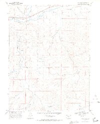
1969 Map of Cow Creek
USGS Topo · Published 1972About this map
The Yampa River and the Denver and Rio Grande Western railroad corridor define the northern boundary of this high-country landscape, where the confluence with the Elk River marks a critical junction in the regional drainage system. To the south, the terrain is shaped by a complex network of tributaries including Trout Creek, Cow Creek, and Foidel Creek, which feed into the primary river valley. Human modification of the arid environment is evident through extensive irrigation infrastructure, notably the Homestead Ditch No 4 and Connell Ditch, alongside the Whetstone Reservoir. Industrial activity in the late 1960s is represented by scattered Oil Wells, a Drill Hole, and multiple Gravel Pits, indicating a period of resource exploration and infrastructure maintenance. The presence of Saddle Mountain provides a prominent landmark overlooking the valleys and seasonal streams like Fish Creek and Middle Creek.
Find a feature on this map
18 named features on this map. Tap any name to fly to it.
Don’t see what you’re looking for? This feature index may not catch every label — zoom into the map to look around manually.
Map Details
Editions of this 1969 Cow Creek Map
2 editions found
Other maps of this area

1911 · Hahns Peak
USGS Topo · 1:125,000

1913 · Hahns Peak
USGS Topo · 1:125,000

1923 · Pilot Knob
USGS Topo · 1:62,500

1924 · Mt. Harris
USGS Topo · 1:48,000

1925 · Pilot Knob
USGS Topo · 1:62,500

1926 · Mount Harris
USGS Topo · 1:62,500

1954 · Craig
USGS Topo · 1:250,000

1957 · Craig
USGS Topo · 1:250,000

1958 · Craig
USGS Topo · 1:250,000

1960 · Craig
USGS Topo · 1:250,000