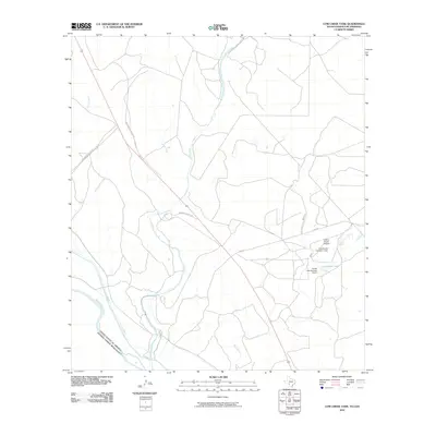
2010 Map of Cow Creek Tank
USGS Topo · Published 2010About this map
Rio Grande defines the international boundary between Maverick County, Texas, and the Mexican state of Coahuila in this 21st-century survey. The landscape is primarily a drainage basin for numerous tributaries flowing toward the border, including Pinto Creek, Goat Creek, and Derramadero Creek. Human presence is largely defined by ranching infrastructure and private aviation, centered around the Frerich Ranch Airport and nearby water management features like Frerich Lake Number 1 Dam and Frerich Lake Number 2 Dam.
Find a feature on this map
17 named features on this map. Tap any name to fly to it.
Don’t see what you’re looking for? This feature index may not catch every label — zoom into the map to look around manually.
Map Details
Editions of this 2010 Cow Creek Tank Map
This is the sole edition of this map. No revisions or reprints were ever made.
Other maps of this area

1941 · Standart
USGS Topo · 1:62,500

1941 · Tequesquite Creek
USGS Topo · 1:62,500

1943 · Standart
USGS Topo · 1:62,500

1943 · Del Rio
USGS Topo · 1:62,500

1944 · Sycamore Ranch
USGS Topo · 1:62,500

1944 · Tequesquite Creek
USGS Topo · 1:62,500

1958 · Del Rio
USGS Topo · 1:250,000

1964 · Del Rio
USGS Topo · 1:250,000

1972 · Del Rio SE
USGS Topo · 1:24,000
1978 · Mud Creek South
USGS Topo · 1:24,000