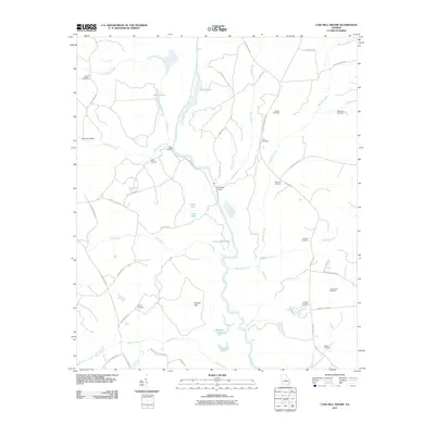
2011 Map of Cow Hell Swamp
USGS Topo · Published 2011About this map
The Oconee River winds through this rural Laurens County landscape, defining a network of wetlands and riverfront activity including Halls Landing and Deep Creek Landing. The terrain is characterized by intricate water systems such as Yorks Dead River, Clear Lake, and Jack Lake, alongside the expansive Tuckers Flat. Local road networks like Old Toomsboro Rd and Old Claxton Rd connect numerous family and community landmarks, providing a clear view of the area's social geography. This survey is particularly significant for genealogical research, documenting many small burial sites such as Londonfield Cemetery, Stanley Cemetery, Guyton Cemetery, and Walker Cemetery. The map also captures several ponds and creeks, including Goat Pond and Big Sandy Creek, illustrating the environmental character of the central Georgia river basin before more recent development.
Find a feature on this map
54 named features on this map. Tap any name to fly to it.
Don’t see what you’re looking for? This feature index may not catch every label — zoom into the map to look around manually.
Map Details
Editions of this 2011 Cow Hell Swamp Map
This is the sole edition of this map. No revisions or reprints were ever made.
Other maps of this area

1916 · Irwinton
USGS Topo · 1:62,500

1920 · Irwinton
USGS Topo · 1:62,500

1957 · Macon
USGS Topo · 1:250,000

1958 · Macon
USGS Topo · 1:250,000

1962 · Oconee
USGS Topo · 1:24,000

1962 · Irwins Crossroads
USGS Topo · 1:24,000

1964 · Macon
USGS Topo · 1:250,000
1973 · Toomsboro
USGS Topo · 1:24,000

1974 · Cow Hell Swamp
USGS Topo · 1:24,000

1974 · Dudley
USGS Topo · 1:24,000