
1962 Map of Irwins Crossroads
USGS Topo · Published 1963About this map
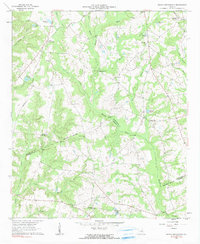
Irwins Crossroads serves as a central landmark in this 1960s rural landscape where the Ohoopee River and its numerous tributaries, such as Dyers Creek and Kelly Branch, define the topography. The region is dotted with many small churches and community cemeteries that provide valuable anchor points for genealogists, including Bethesda Ch, Beach Grove Ch, and Mt Pleasant Ch. A distinct boundary line separates Washington and Johnson counties, following the river through a network of family-named water features like Hodges Pond and Youngs Pond. River crossings such as Harts Ford Bridge and Johnson Bridge indicate the established local transport routes of the era, while the presence of Peacocks Crossing suggests the historical intersections of road and rail that once supported the local agriculture and timber trade in this portion of Middle Georgia.
Find a feature on this map
38 named features on this map. Tap any name to fly to it.
Don’t see what you’re looking for? This feature index may not catch every label — zoom into the map to look around manually.
Map Details
Editions of this 1962 Irwins Crossroads Map
2 editions found
Other maps of this area

1957 · Macon
USGS Topo · 1:250,000

1958 · Macon
USGS Topo · 1:250,000

1962 · Oconee
USGS Topo · 1:24,000

1962 · Tabernacle
USGS Topo · 1:24,000

1962 · Sandersville
USGS Topo · 1:24,000

1964 · Macon
USGS Topo · 1:250,000
1973 · Riddleville
USGS Topo · 1:24,000
1973 · Harrison
USGS Topo · 1:24,000

1974 · Cow Hell Swamp
USGS Topo · 1:24,000

1974 · Wrightsville
USGS Topo · 1:24,000