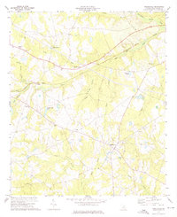
1973 Map of Riddleville
USGS Topo · Published 1976About this map
Riddleville serves as the primary hub of this 1970s rural landscape in southern Washington County, where the topography is defined by the branching tributaries of the Little Ohoopee River and Williamson Swamp Creek. The settlement pattern is deeply connected to local faith and community centers, with numerous country churches such as Henderson Grove Ch, Green Grove Ch, and Mt Mariah Ch spaced across the countryside. The presence of several smaller water features, including Smith-Jordan Pond and Johnsons Pond, alongside the drainage of Tippie Branch and Gully Branch, illustrates the well-watered nature of these coastal plain uplands. A Lookout Tower stands as a prominent landmark near the town center, while the Washington County Memorial Garden and the small settlement of Tanner anchor the northwestern reaches of the map.
Find a feature on this map
24 named features on this map. Tap any name to fly to it.
Don’t see what you’re looking for? This feature index may not catch every label — zoom into the map to look around manually.
Map Details
Editions of this 1973 Riddleville Map
2 editions found
Other maps of this area

1953 · Athens
USGS Topo · 1:250,000

1957 · Macon
USGS Topo · 1:250,000

1958 · Macon
USGS Topo · 1:250,000

1958 · Athens
USGS Topo · 1:250,000

1959 · Athens
USGS Topo · 1:250,000

1961 · Warthen
USGS Topo · 1:24,000

1962 · Irwins Crossroads
USGS Topo · 1:24,000

1962 · Sandersville
USGS Topo · 1:24,000

1963 · Athens
USGS Topo · 1:250,000

1964 · Macon
USGS Topo · 1:250,000